Grant: 24-012C
Project Title: Submeter units for more accurate nest GPS location in Gulf of Mexico
Project Manager: Melissa Macksey
Organization: Mote Marine Laboratory (Non-Profit Organization)
Grant Amount: $9,752.75
Completion Date: 2024-12-09
Summary: Mote Marine Laboratory's Sea Turtle Conservation & Research Program (STCRP) has monitored sea turtle nesting in Sarasota County since 1982. Annually, from April 15 through October 31, 56 km of nesting beach is surveyed daily across five separate islands (Longboat Key, Lido Key, Siesta Key, Casey Key, and Venice). STCRP maintains one of the most (if not the most) complete, accurate, and long-term data sets on the west coast of Florida. Sarasota County contains the largest loggerhead rookery in the Gulf of Mexico, in 2023 on Casey Key loggerheads laid 152 nests per km. All of STCRP's monitored nesting beaches are part of FWC's Statewide Nesting Beach Survey and Nest Productivity Assessment, and a portion of Siesta Key is included in the Index Nesting Beach Survey. The data collected from our monitoring have contributed to important sea turtle research by Mote scientists, the Florida Fish and Wildlife Research Institute, and collaborating scientists across the United States. Our dataset has created a baseline for normal nesting and hatching trends against which changes can be identified and tracked. These data form the basis for conservation decisions used to promote the recovery of sea turtle populations and the protection of sea turtle habitats. Submeter-accurate GPS units will allow STCRP to more accurately determine where nests are and will aid us by decreasing the excess waste and extra staff time. Decreasing the amount of staff time on every individual crawl will allow us to get off the beach faster and maintain our high level of consistency.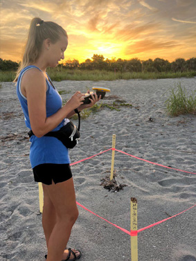 Results: Seven submeter GPS units (Trimble Catalyst DA2) were purchased along with a 3-year subscription for 60cm accuracy data for each unit. There was a bit of a delay in set-up for utilization on the beaches as sync with phones caused app crashing that required some trial and error. We were able to trouble-shoot and develop working instructions by later in the season. By late August, GPS units were taken in the field for several days and waypoints were created for marked nests. At this point, nesting had wound down, but there were still quite a few nests in the field that were able to be marked (Photographs attached on next page of the unit in the field). As Hurricane Helene approached, all marked nests that remained on the beach were documented with the submeter units if they had not already been. Unfortunately, the storm surge from Helene was so great that all remaining nests in our area were deemed total losses. The submeter units were taken back to confirm the loss of each nest. With the details and instructions worked out throughout the course of 2024, we look forward to utilizing the units consistently beginning in April 2025 for a larger portion (if not all) marked nests on our beaches.