Grant: 20-011R
Project Title: Information to Protect Florida's Most Valuable and Vulnerable Sea Turtles from Vessel Strikes
Project Manager: Blair Witherington
Organization: Inwater Research Group (Non-Profit Organization)
Grant Amount: $16,765.78
Completion Date: 2021-11-04
Summary: Sea turtle vessel-strike mortality in Florida has population-level effects and is the most frequent, identifiable cause of death in strandings. This mortality is high in adults near high-density nesting beaches. The goal of this project is to produce information that would change human behavior to reduce this threat. Our objectives are to 1) use transect surveys and distance sampling to develop a �heat map� of sea turtle spatial distributions for a densely occupied area within Florida�s nearshore waters, and 2) leverage FWC Statewide and Index Nesting Beach data to understand linkages between nesting density and in-water abundance and density of strike-vulnerable mating and inter-nesting turtles, which could be extrapolated to the majority (~1300 km) of Florida�s coastal waters. Our study area will be Atlantic nearshore waters between Sebastian Inlet and Jupiter Inlet. We will represent this 108-km distance using 16, 5-km long, shore-perpendicular transects, surveyed twice in May and twice in June (320 km total transect distance) by a research vessel with a sighting tower. This area encompasses some of the most densely nested beaches for loggerheads and green turtles in the United States and has extensive nesting by leatherbacks. We will model data from Distance Transect surveys to estimate turtle density by location, depth, species, and life stage, and will record identifiable sex and behavior that would indicate vulnerability to vessel strikes and operational sex ratios. 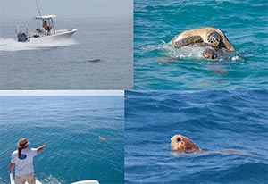 Results: In 2021, we measured sea turtle abundance during eight days of nearshore surveys: four consecutive days in May and four consecutive days in June 2021. The surveys comprised 23, 5-km, shore-perpendicular transects between West Palm Inlet and approximately 20 kilometers north of Sebastian Inlet. We surveyed transects from an 8.2-m vessel with a sighting tower that put the eyes of observers approximately 4.5 m from the water surface. The transects required two days to survey at a vessel speed of approximately 7 knots. During each of the two, four-day sampling periods, the transects were surveyed twice in reversing order. This sampling transected 460 kilometers, which represented an area of approximately 887 km2. We observed 181 individual turtles at or near the surface. These turtles comprised 84 Loggerheads (15 adult females, 2 adult males, 58 sex-unidentified adults, 9 sub-adults); 95 Green Turtles (24 adult females, 21 adult males, 42 sex unidentified adults, 8 juveniles); and two adult female Leatherbacks. Additional data included GPS position, side of vessel, perpendicular distance from transect, depth below surface (surface, 1-m depth, or deeper), behavior and association with other turtles (e.g., mating, guarding, courting). The model estimated that there were 3218 turtles (95% CI 2258�4586) over the study area during the survey period. The model indicated that nearly 80% of these turtles were within three km of shore and demonstrates the relative densities of each county.